The Harris County Flood Resilience Plan
What is It?
The Harris County Flood Resilience Plan is the County’s first comprehensive county-wide planning effort to advance flood resilience in the region. It provides a forward-looking, actionable plan designed to safeguard the well-being of communities facing the physical, social, and economic hardships of flooding.
The Flood Resilience Plan is developed by the Harris County Infrastructure Resilience Team (IRT), an interdepartmental, multidisciplinary team with representatives from the Flood Control District (lead agency), Harris County Office of Homeland Security and Emergency Management, Office of the County Engineer, Housing and Community Development, Harris County Public Health, and Harris County Toll Road Authority. This plan also builds upon the work done by the Community Flood Resilience Task Force (CFRTF).
With an expected completion date of February 2027, the Flood Resilience Plan will propose implementation-focused short, medium, and long-term actions to strengthen infrastructure systems, natural/ecological resources, and community networks.
Why It's Important
The County’s first Flood Resilience plan provides a clear set of recommendations and practical steps to:
- help individuals, property owners, businesses, non-governmental organizations, and government agencies across the county to improve flood resilience, and
- augment traditional flood mitigation projects by considering programs, policies, nature-based solutions, and community capacity building.
Public Meetings
The public meeting for our area is scheduled for October 1, 2025 at the Steve Radack Community Center. See the calendar for additional details.
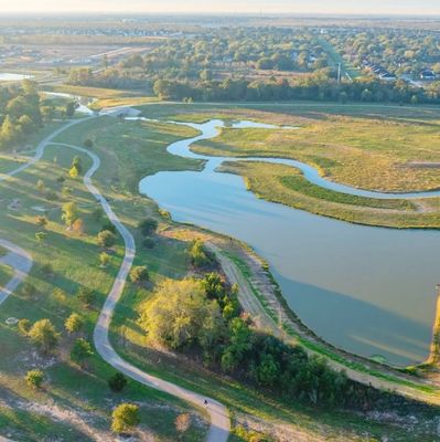
Detention "Compartments" Planned for Upper South Mayde Creek
Upper South Mayde Creek Detention Basin to be Constructed in Fall 2024
In its community engagement meeting on February 26, 2024, Harris County Flood Control District announced that the Upper South Mayde Creek detention basins (known as Bond Project C-48) will begin construction in the fall of 2024, with completion expected about 12 months later.
The detention basin will be comprised of 4 compartments: W2, W3 (North and South) and W4. The total storage capacity of these compartments is 181 acre-feet. The project area is located along South Mayde Creek and is bordered by Peek Road on the west, Grand Parkway on the south, and Stockdick School Road on the north.
While the surrounding areas will see a reduction in flood risk as a result of this project, the largest benefits will be seen in the neighborhoods downstream of the project, including Westlake Place, Westlake Forest, and Sundown Glen, and roadway crossings at Clay Road, Raintree Village, and Greenhouse Road.
Construction funds come through the Community Development Block Grant for Mitigation Program (CDBG-MIT). A feasibility study was completed by HCFCD in 2017, and a Preliminary Engineering Report was presented to Harris County Commissioners’ Court in October 2021.
There are no proposed recreational amenities for this area at this time. However, there are plans for a trail along the maintenance berm.

South Mayde Creek's 2 Flood Mitigation Projects Advance
Lower South Mayde Creek Recommended by SJRFPG, Flood Control Advances Upper South Mayde Creek Detent
The San Jacinto Regional Flood Planning Group recommended Harris County Flood Control District's flood mitigation project for Lower South Mayde Creek (C-36) as part of its Final Regional Flood Plan, adopted in January 2023.
The 86th Texas Legislature passed Senate Bill 8 in 2019 which authorized and established the regional and state flood planning processes and assigned the responsibility for the flood planning process to the Texas Water Development Board (TWDB). The San Jacinto Regional Flood Planning Group (San Jacinto region) is one of the 15 Regional Flood Planning Groups (RFPGs) formed by the TWDB. The TWDB will compile these regional plans into a single statewide flood plan and will present it to the Legislature in 2024.
The Harris County Flood Control District will move forward on one of the three detention basins included in the Upper South Mayde Creek flood mitigation project. Additional details will be provided as they become available.
Texas GLO Awards Harvey Funds Directly to Harris County
Funding Intended to Support "Partnership" Projects for HCFCD
On March 18, 2022, the U.S. Department of Housing and Urban Development (HUD) approved the Texas General Land Office’s (GLO) amended plan for Community Development Block Grant Mitigation (CDBG-MIT), which allocates $750 million in funding for Harris County and an additional $488 million to the Houston-Galveston Area Council for additional mitigation projects in the region.
In addition to the $750 direct allocation, HUD awarded $62 million to the City of Houston. There were additional awards of $117 million in CDBG-MIT (Flood Mitigation) awards for Harris County projects, plus $209 million in infrastructure funds from CDBG-DR (Disaster Recovery).
The GLO came under pressure from Congress and local leaders in 2020 when it announced that Harris County would receive zero dollars of the $1 billion of federal relief funding related to the storm. Harris County requested $1.3 billion for various projects from the first round of Hurricane Harvey relief funds distributed by HUD. Houston and Harris County sustained roughly half the damage Harvey inflicted on Texas, and Congressional representatives argue that the region, as a consequence, should have received half the aid.
Federal funding is critical to the successful implementation of Harris County's 2018 bond program. When the Bond Program was first envisioned, the Flood Control District identified partnerships as a continued, vital source of funding and resources to move initiatives forward. While the bond was for $2.5 billion, the full cost of every project in the bond program as passed by Harris County voters is nearly $5 billion. From the outset, there was an anticipated need for funding partners to fully construct the projects on the list. Without partnership funding, every bond program project has sufficient funding to get started (approximately 10% of the cost) - but not completed, as the partner (in this case HUD) was expected to contribute 90% of the funding.

Lower South Mayde Creek Bypass (C-36)
Project Description
The “South Mayde Creek Channel Conveyance Improvements and Bypass Channel” (C-36) is made up of two components: (1) a widening and deepening of South Mayde Creek west of the Greenhouse Road bridge, starting at Fry Road; and (2) the construction of a bypass channel on the east side of the Greenhouse Road bridge, extending to Barker Cypress Road.
The purpose of channel expansion west of the Greenhouse Road bridge is to increase the conveyance capacity of South Mayde Creek.
The bypass is an additional waterway that will be constructed east of the Greenhouse Road bridge. The purpose of the bypass is to convey the additional flow of stormwater into the Addicks Reservoir during more severe storm events. The existing channel will continue to convey water during normal rainfalls.
HCFCD recognizes there will be a number of challenges to the bypass, and the final configuration has not been determined. Some of the challenges are:
- The bypass will intersect a channel that flows north-south from Morton Road,
- It will also cross Groeschke Road at the trail entrance to Cullen Park .
- The water volume and velocity when the bypass rejoins South Mayde Creek just before the Barker Cypress Road bridge is uncertain.
- Sediment will be transferred downstream. The Corps of Engineers will require sedimentation basins to be constructed.
The project also includes the construction of two wet bottom detention basins near South Mayde Creek to mitigate the potentially adverse impacts of the channel improvements by temporarily storing excess stormwater - and then slowly draining when channel water levels recede.
It should be underscored that this project is in a preliminary engineering stage, and changes to the design are not unexpected. HCFCD expects to work through the bypass challenges and model alternatives for the next few months. The PER will be completed in the spring of 2020, and properties for the two stormwater detention basins will be acquired. No timeline has been established for the detailed design and construction of the bypass, but detailed engineering for the detention basins is to begin in the summer of 2020. A start date for construction has not been determined.
May 2023 Update
The San Jacinto Regional Flood Planning Group recommended Harris County Flood Control District's flood mitigation project for Lower South Mayde Creek (C-36) as part of its Final Regional Flood Plan, adopted in January 2023.
The next milestone will be in July 2023, when the Regional Flood Planning group adopts an Amended Regional Flood Plan - before submitting to the texsTexas Water Board (TWB). TWB will consolidate the regional plans into a state plan and present to the Texas Legislature in 2024.
Addicks Reservoir Channel De-Silt and Repair Program (F-53)
Project Description
The Addicks De-Silt Program consists of multiple comprehensive projects to evaluate and de-silt channels for which the District has property rights that drain directly to the Addicks reservoir. In addition, this program will repair impacts, and develop construction and maintenance plans, in coordination with the U.S. Army Corps of Engineers as appropriate.
The goal of this program is to make sure these channels are functioning at design capacity as they carry stormwater out of surrounding neighborhoods and into the federal reservoir. Rainfall within the 138-square-mile Addicks Reservoir watershed drains along 159 miles of open waterways, including Langham Creek (U100-00-00), South Mayde Creek (U101-00-00), Bear Creek (U102-00-00), Horsepen Creek (U106-00-00), and its tributaries. As a part of the Flood Control District’s overall maintenance operations, this program follows the Tax Day 2016 and Hurricane Harvey storms, which sent record levels of sediment-laden stormwater through the channels leading into the reservoir, and caused severe erosion in some areas.
To learn more about this project and other Flood Control District efforts in the area, please visit www.hcfcd.org/F53.
July 20, 2020 - HCFCD reports that the District has removed over 100,000 cubic yards of silt, sediment, and debris. The largest volume removed was in Langham Creek, with 64,579 tons removed, followed by South Mayde Creek with 32,298 tons (or 3,200 dump trucks) removed. Crews are continuing work on this construction project to remove silt and debris from these 2 creeks, plus Bear Creek and Horsepen Creek to help return these waterways to their original design capacity.
October 3, 2019 - HCFCD held a community engagement meeting is to discuss the rehabilitation of channels upstream of Addicks Reservoir.

Desilting Project - Pilot Project (Completed) and There Packages to be Completed